 Image 1 of 2
 Image 2 of 2
The Mantario Hiking Trail travels over Precambrian rock and forest. Although primarily in Manitoba, the trail briefly crosses the border into Ontario at Caribou Lake East Campsite. The trail passes a mix of jackpine and black spruce sprinkled into large stands of Trembling Aspen. Keep an eye out for tamarack in wetter areas. Lakes scattered through the trail are easily accessed from campsites and offer great opportunities to fish for walleye and northern pike.
If you’re looking for a good day trip or overnight in-and-out, hikers can start at the Southern Trailhead and hike 9.7 km north to Caribou Lake West Campsite; expect a seven-hour round trip. The Mantario Trail is marked by signs with white arrows on a blue background. Portage trails between lakes are marked by triangular signs with black arrows on a yellow background.
This purchase comes with the following:
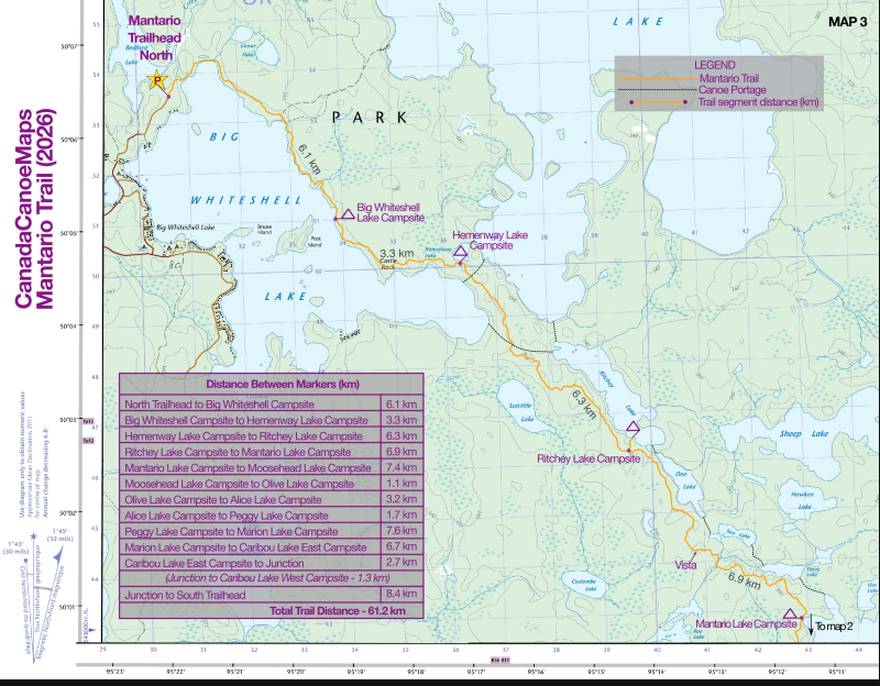
One 8.5×11 inch quad-fold 1:50 000 topographical map of the Mantario Trail
Route information sheet that includes access, egress, risks and considerations for the trail.
Elevation chart for planning direction of travel.
The map itself contains:
Hiking route, campsites, portage routes, access, egress, and points of interest.
Distances between each campsite.
The Mantario Hiking Trail travels over Precambrian rock and forest. Although primarily in Manitoba, the trail briefly crosses the border into Ontario at Caribou Lake East Campsite. The trail passes a mix of jackpine and black spruce sprinkled into large stands of Trembling Aspen. Keep an eye out for tamarack in wetter areas. Lakes scattered through the trail are easily accessed from campsites and offer great opportunities to fish for walleye and northern pike.
If you’re looking for a good day trip or overnight in-and-out, hikers can start at the Southern Trailhead and hike 9.7 km north to Caribou Lake West Campsite; expect a seven-hour round trip. The Mantario Trail is marked by signs with white arrows on a blue background. Portage trails between lakes are marked by triangular signs with black arrows on a yellow background.
This purchase comes with the following:
One 8.5×11 inch quad-fold 1:50 000 topographical map of the Mantario Trail
Route information sheet that includes access, egress, risks and considerations for the trail.
Elevation chart for planning direction of travel.
The map itself contains:
Hiking route, campsites, portage routes, access, egress, and points of interest.
Distances between each campsite.